In late March, reporters for the Vineyard Gazette set out along the shorelines of the Island to see what the latest gale had left behind. And what it had taken away.
It had been a hard winter with one blustery northeaster after another. But this last tempest, a two-day storm that intruded rudely on the earliest days of spring, had been “the final straw,” the newspaper said. It was destructive to the coastline and demoralizing to inhabitants.
The writers walked along the south shore, the inlets of Chappaquiddick, around the ponds and up and down Vineyard Sound beaches. They returned to their desks awed by what the ocean had beaten up and carried off.
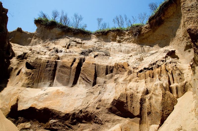
Where cliffs rose above the sea, storm waves had reached over the shore and clawed away the foundations of the bluffs. The faces of the embankments were showing signs of fracture, and it was clear how the heights of the banks would soon slump down to the bases.
“In other places, the landslides caused by such undermining had already occurred, and boulders the size of small automobiles had been loosened to roll down to the beach below, along with quantities of earth,” one reporter wrote.
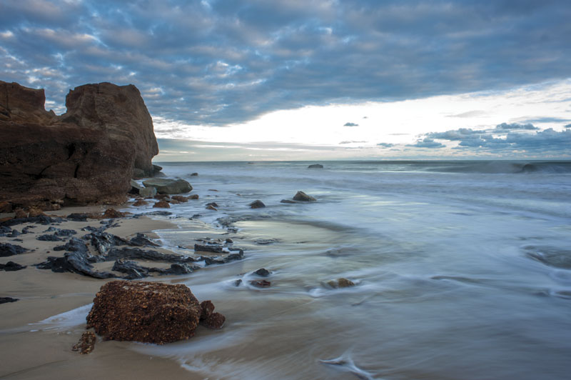
The storm had opened Edgartown Great Pond to the sea in six or seven places. It had spread broad fans of sand into neighboring ponds, shrinking them noticeably. It had flattened dunes that once protected the whole length of Chilmark Pond from the ocean. It had left beaches cobbled with stone and had cut off walkways around headlands and points. Summer residents would soon return and notice that their houses now lay feet, if not yards, closer to the edges of promontories than they had the Labor Day before.
This was the front-page news on March 28, 1958. Alarming, but perhaps not surprising. Fifteen months earlier, on Dec. 14, 1956, the Gazette had published an editorial titled “For Erosion Control.” It called for a complete survey of the Island coastline to determine how much of it had been lost in recent years and how what remained might be saved.
“Ironically, most of the land lost into the sea in older times was not considered of great value, for there was plenty more land,” the editors wrote. “Today erosion destroys property of great value every winter, and there is still no way of knowing how much the shellfisheries are likely to suffer from the shoaling of some areas, the overshot of the sea into various ponds, and other inroads characteristic of erosion.”
But the story of losses to the Atlantic did not begin there.
A quarter century earlier, in December 1932, the Gazette observed: “The run of tides that we have had lately are higher than the oldest inhabitant recalls, except when there has been a storm or breeze blowing. The beaches look several feet lower than they have a couple of months ago, and the water stands much further inshore than it did before.”
Forty years earlier, in the summer of 1891, Henry L. Whiting, chief of the U.S. Coast and Geodetic Survey and a resident of West Tisbury, published a report on erosion around the Vineyard.
He noted at Cape Pogue on Chappaquiddick that the “summit of the sandy bank or bluff nearest to the lighthouse is now within about forty-five feet of its foundation and wasting rapidly.” Thirty years before, the base of this embankment had been armored with rocks. But now, Mr. Whiting wrote, “The shoreline of this ridge of stone can be seen under water from the top of the bank, from 500 to 600 feet beyond the present line.”
And so on backward to about 6,000 years ago.
That was when the dirty, sloping face of the last glacier had long retreated beyond the northern horizon. Torrents of meltwater had filled the distant ocean, which had risen hundreds of feet, and a hundred miles, to flood the old, dry coastal plain on which the Vineyard lies today.
The ocean was choosing which nearby islands to drown (among them today the underwater sand dunes of Georges Bank and Nantucket Shoals), which to merely surround (Martha’s Vineyard and Nantucket, among our many neighbors) and which to leave wavering uncertainly between the status of island and shoal (Skiff’s, off the southeast corner of Chappaquiddick).
As Islanders reflect this summer on the legacies of their own latest, toughest winter of slumping bluffs, flattened dunes, narrowing beaches, shoaling ponds, fallen boulders, and imperiled homes, it is tempting to think of erosion as a ramification of storms alone.
Coastal experts say that would be a profound mistake. The sea that reached the Vineyard five or six millennia ago continues to rise and remake the Island today, hollowing from cliffs to build beaches, siphoning from beaches to nourish shoals. Storms only punch up the quieter erosive work that the rising sea is doing every day. A letter to the editor of the Gazette from Edward Higbee of Vineyard Haven summed it up in 1956:
“That the shorelines of the Vineyard are eroding is nothing new or strange. The glaciers made this Island of the most easily removable stuff. This pile of photogenic gravel dumped in the sea is here on a temporary loan. As the Arctic ice pack continues to melt, the level of the excavating tide rises accordingly.
“It is strange that man, such an impermanent fixture himself, should be distressed about the impermanence of an Island. The Vineyard has been on its way out to sea since the day it was born and its erosion began. Some of its most beautiful beaches are the byproduct of that erosion now caught in the act of chewing up a fresh source of supply. Within a few thousand years the unfinished job will be completed and we will all be relieved of worrisome investments.”
In broad geological terms, scientists and coastal engineers say, the Island was rubble on the coastal plain yesterday, is Martha’s Vineyard today, will be Skiff’s Island tomorrow — and all except its highest and rockiest hills, George’s Bank a few days after that.
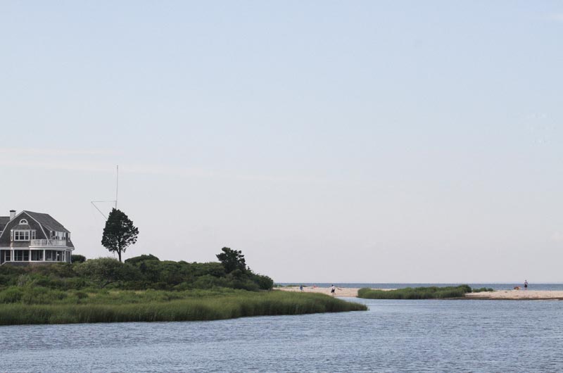
But people are taking especially keen notice of it all right now because the bluffs and beaches — falling back and folding inland before the ever-rising sea — have begun to encroach on things that were built a few years or decades back, things we imagined would always be safe: Our lighthouses. Our coastal roads. Our wharves and piers. Our public beaches. And our phenomenally expensive seafront homes.
With respect to many coastal properties, the Vineyard has now officially entered the era of retreat. And the first lesson we are learning is that as far as the Atlantic Ocean is concerned, there is no such thing as erosion control.
Dump Site on the Way to the Sea
Two men on Cape Cod have spent much of their careers studying how the shoreline in this corner of the world responds to the rising sea. Speaking this summer to the Gazette, they demonstrate a talent for putting the everyday work of erosion and the costly predicament of humans into lively juxtaposition.
Graham Giese is director of the Land and Sea Interaction Program at the Provincetown Center for Coastal Studies. Ted Keon is coastal resources director for the town of Chatham.
“Before World War II, most people bought or built year-round or summer houses in or near a village,” Mr. Giese said. “This changed after the war. A lot of houses on the Vineyard and on the Cape were built after World War II, many near a bluff or a beach.”
Mr. Giese said people who built near the shore in those days had a general sense that beaches and cliffs erode, but they looked around and built far enough back to where “it felt okay.”
Mr. Keon said: “I don’t know that it was conscious — ‘I’ll give myself 50 years of erosion’ – or that ‘I bought my lot, the lot is this big, and I’ll put the house here.’” Rather, he suggested it was a general sense among these coastline pioneers that the history of a place begins with their discovery of it.
“And so nature’s caught up with that, and it’s caught up with them all at the same time,” Mr. Keon said. “In addition, new homes are coming in and people like to be near the shore, and they built near the shore and the time frame isn’t 40 or 50 years. The time frame is two or three years.”
Both men said erosion is not so much a process of the rising Atlantic taking earth and sand away from us. Instead it is a process of conveying that earth and sand to the last stop, the place where it’s always really belonged — the flooded coastal plain on which our geological foundation rests.
“The total process involves the glaciers retreating and climate warming, and then the seas rising, and then the seas cutting that material away and incorporating it into the continental shelf,” Mr. Giese said. “So, in a sense, you could say that the Cape and the Islands are not eroding; they’re building — it’s part of continental building. We’re part of the construction.”
Mr. Keon smiled. “As a proactive beach nourishment person in many ways,” he said of himself, he must now expand his thinking. “The glacier was the dump truck bringing sediment, now it’s our job to push that sand around. We’re the source of the nourishment for the rest of the continental shelf!”
Losses This Year
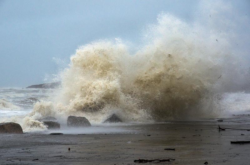
The past winter was a rough one, with 10 easterly storms striking between the end of October and the end of March. The first was Sandy, on Oct. 29, the storm that famously wreaked devastation on Manhattan and the New Jersey coastline. But in this part of New England, Sandy did not howl as loudly, flood as deeply or erode as dramatically as many of the gales that followed.
In February, Clarissa Allen, who owns Allen Farm stood on the shoreline at Lucy Vincent Beach, in Chilmark, a place where in the time of her father Roger, sheep and horses had grazed. In the 1920s and 1930s the high cliffs ennobled almost the whole length of the southwestern coastline and heaved their way down to a distant ocean shore, here steeply, there gently.
Those cliffs along Lucy Vincent were long gone as of this winter. Where Ms. Allen stood looking out to the encroaching Atlantic, a low spine of bluffs had still edged hopefully along the beach just a few months before. Yet except for the remnant hump of a headland rising a hundred yards to the east, the rest was now all beach, flat as the Sea of Tranquility.
“This is extremely dramatic since last autumn,” Ms. Allen said. “There were slight dunes here. There had been a lot of funky little restoration projects with twigs and Christmas trees to build up the dunes.”
Winter storms had backhanded them into oblivion. Combers crashed into the remaining lonely bluff, broke off half of its seaward face and dropped it into the froth. Bursting over the top, surf raced down the backside and over the rest of the flattened beach, flooding the western arm of upper Chilmark Pond. Along the way, the surge swept heavy stones to one side, exposed flats of peat and ripped and salted whole stands of viburnum, blueberry and ragweed to brushy skeletons.
Asked if she felt sad about all the years she once put into building up the dunes, Ms. Allen said: “I’m over that. I’ve had that response. I always think that if you throw your heart and soul into something and work really hard you can effect some kind of change, usually for the positive. I thought I’d done that a lot here. . . . But I’ve given up. Obviously we lost.”
In early May, Cong. Bill Keating paid a visit to the Vineyard to see what the storms had done to things that Islanders depend on every day.
In Vineyard Haven, a seawall that defends a road bordered by the harbor on one side and the lagoon on the other had begun to crack from the blows landed by a parade of northeasterly storms. At East Chop, the seaward lane of a pretty coastal drive was closed because the embankment beneath it was faulting and sliding from the assault of the winter gales. At the northern inlet to Sengekontacket Pond, the harbor master’s boat nearly grounded because of shoaling, a legacy of strong currents and heavy winds all season long.
“It’s frustrating — how do we keep our beaches from disappearing?” asked Walter Vail, an Oak Bluffs selectman. “It’s economically imperative to have these things because if we don’t get the tourists, we’re dead.”
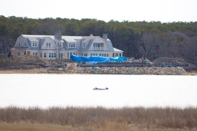
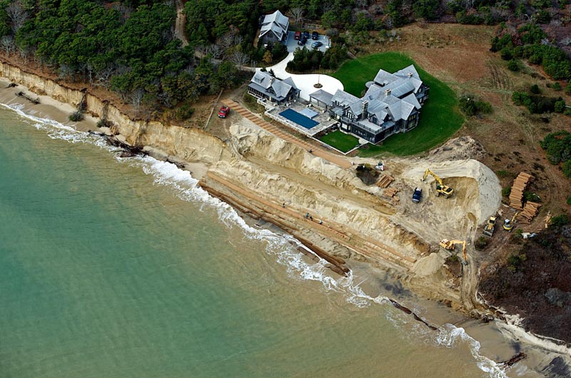
One area affected spectacularly was the southern Chappaquiddick coastline and a large home that was built on the embankment of Wasque Point in 2007.
In 2010 an opening through a nearby barrier beach began to deprive the bluffs at Wasque of the sand and beach that had once protected them from direct attack by the Atlantic. Two years later, the southern flank of Chappy had lost up to 400 feet of ocean-facing beach, a pond that lay behind it and 80 feet of the coastal embankment on which the house owned by Richard and Jennifer Schifter stood.
As the winter gales of 2012-2013 thundered in, the bluffs began losing an average of another foot of earth a day. The Schifter house, which had rested 230 feet from the edge of the cliff when built, was suddenly only 25 to 40 feet back after the last northeaster whirled out to sea on March 7. Emergency permits from Edgartown in hand, the owners embarked on a colossal effort to move the house, intact, through a vast manmade trench to temporarily safer ground some 275 feet inland.
The frequency and strength of the winter storms, the startling recession of beaches and loss of bluffs all around the Island and the epic Schifter operation provided a backdrop for the finding in the Harris Interactive poll conducted this spring by the Vineyard Gazette: 64 per cent of Vineyard residents, year-round and seasonal, see coastal erosion as their greatest single worry about life on the Island.
Role of a Barrier Beach
Clarissa Allen looked at the disappearance of the highlands and cliffs where her father pastured sheep and said: “We lost.” But the fact remains that because of the loss from a bluff, a beach on the Vineyard coastline almost always gains.
When ocean surf washes over a beach to pull away the base of an earthen cliff, it converts much of this dug-out rock, clay, dirt and grit to sand, coastal geologists say.
In a process known as sediment transport, wind and waves create a current and move much of the sand in a sawtoothed pattern down the coastline. The surf spreads the sand at an angle across the beach, building it up. But Mr. Giese and Mr. Keon note that the retreating waves also pull some of it directly back to feed the offshore shoals and sandbars of the submerged continental shelf.
There is a seasonal rhythm to this process, noticeable to those who walk South Beach year-round. In winter, the height and strength of the waves tend to drag more sand offshore than they deliver onshore. The beach narrows and scarps, widening and flattening again only when the waves of summer ease, returning more sand to the shore than they take away.
Gales interrupt and quicken the pattern with northeasters in winter and spring and tropical storms in summer and fall. What people see immediately is what a storm cuts into and takes away. But the process is not quite as simple as that, said Jeff Donnelly and Andrew Ashton, scientists in the geology and geophysics department at the Woods Hole Oceanographic Institution. They specialize in how changes in the climate can also change a coastline.
We think of storms as evil eroders, but really storms are also builders,” Mr. Donnelly said. “And they’re essential in terms of keeping [beaches] building vertically and keeping up with sea level rise.” Storm waves wash over dunes and beach to build up the backside of a shoreline — the landward direction in which the beach is retreating anyway because of the inexorable rise of the sea.
Mr. Ashton agreed. “This is what has to happen for the barriers to continue to exist there,” he said. “In some cases, you want a ton of overwash so you can keep those land forms [beaches and the ground behind them] intact. We’re finding in more of our research that if you don’t get that overwash, with storms throwing sand over the back [of the beach with] sea level rising, that’s how you drown your landforms in place.”
The most harmonic and efficient defense against a rising sea is an unarmored and unaltered barrier beach folding itself inland day by day, slowly in peaceful periods and more rapidly in stormy ones, the coastal experts say.
Jo-Ann Taylor, coastal planner for the Martha’s Vineyard Commission, has long studied this process. “We know from the historic erosion rates, there’s a foot to a foot and a half [of retreat per year] on the Gay Head side, and then as you move down the south shore, you get to Chilmark Pond, and you’ll be at two and a half to three feet a year,” she said. The material at the western end of the southern shoreline is coarse, and farther east it grows finer and more easily movable.
“And as you move toward Tisbury Great Pond, it’s four or five feet a year,” Ms. Taylor said of the beach recession. “Six or seven feet a year when you’re down to Edgartown Great Pond. And then when you get down to the public part of South Beach, that’s about 10 or 12 feet a year. It’s because it’s the finer part of the outwash plain.”
Beaches narrow and widen with the seasons, but when bluffs erode and rocks and earth fall into the sea, they’re gone until the next glaciation returns with more rocks and earth to build them up again, scientists concur. Hence the retreat of the coastline as a whole.
There is naturally a conflict when the rolling in of a beach or tumbling back of a bluff reaches a home or road or something else in which people have made a sizeable investment.
“The work of waves is to adjust the shore to the rise in the sea level,” said Mr. Giese of the Provincetown center. “We’ve been living with sea-level rise long-term — and by long-term I mean a decadal-to-century scale — of about a foot per hundred years. We could dismiss that, but that in itself has something to do with what happens when there are houses [in the way].”
Rates of the Rising Sea
With the warming of the planet, the rate of sea level rise has increased significantly in the last hundred years. The only issue is whether the rate will continue to increase in this century. Thirteen years in, there is debate.
But few dispute that the rise itself will continue. Scientists interviewed by the Gazette agree that relatively brief changes in weather patterns and sea conditions might make the rate look and feel either greater or less as the century moves along.
When the Atlantic finished surrounding Cape Cod and the Islands 6,000 years ago, it still lay nearly 20 feet lower than it does now, said Mr. Ashton of Woods Hole. At that point, what had been a torrid rise for millennia slowed notably to only about three feet per thousand years, bringing the sea level roughly up to where we are today.
Then beginning about 125 years ago, the rate suddenly surged again to a bit more than a foot per century. Scientists attribute about half this rate to a process called subsidence, a long-term lowering of the crust in our quadrant of New England following the retreat of the glacier.
So some of the rise of the sea can be tracked to prehistoric and uncontrollable geological causes. And the newest jump in the rate started just before man began adding a great deal of carbon dioxide to the atmosphere in the 20th century.
“There’s really compelling evidence now, globally, that this inflection in the rate of sea level rise actually occurs between 1875, say, and 1900,” said Mr. Donnelly. “And so that’s something of a puzzle. It’s ahead of the temperature-based response. We don’t really have a good answer. Nevertheless, this increase in rise is unprecedented in the last several millennia. We haven’t seen rates like this in probably at least 6,000 years.”
With the global rate tripling in the last 130 years from the rate of the previous 6,000 years, it is possible that it will triple again, to a rise of three feet in the next hundred years, according to a recent report of the Intergovernmental Panel on Climate Change (IPCC), sponsored by the United Nations.
Some doubt this.
“Do we see any evidence of acceleration? I’ve brought up that point as a way of questioning whether the high-end estimates could be correct,” said Rocky Geyer, chairman of the applied ocean physics and engineering department at the Woods Hole Oceanographic Institution.
“When you look at the IPCC predictions, they do have quite a lot of curve to them — there’s this acceleration of sea level rise,” he continued. “Can we tell whether we’re off or on that extreme curve? Well, the answer is no, we can’t tell. If we come back 10 years from now, a little more gray hair, we’ll be able to say whether the extreme IPCC predictions are wrong. We can’t say now.”
There are also short-term variations to consider.
“On the one-year time scale, weather is important,” Mr. Geyer said. “Between a one and several-year time scale, oceanographic processes are important. If the Gulf Stream changes speed, it changes sea level. And, in fact, in the next 20 years, what the Gulf Stream does is way more important than what global temperature does.”
Mr. Donnelly takes a different view.
“It doesn’t look good,” he said, pointing to satellite data estimating mean sea level around the world. The data confirm that the current rise is “already on the upper part of that trajectory. . . . The whole notion that we were potentially going on these different pathways and [might still have] a more modest rate seems to be completely blown out of the water,” he said.
Construction of Shoreline Defenses
On the Island, the first grand efforts to engineer things along the coastline began at the start of the 1900s. As part of a huge statewide effort costing $70 million, the board of harbor and land commissioners authorized the opening of a freshwater lake at Oak Bluffs and the dredging of a creek at Menemsha to create the harbors known there today.
Ever since, towns and citizens on Martha’s Vineyard — and everywhere else along the seaboard — have been building jetties to keep harbors open, seawalls to hold coastal embankments in place and stone or wooden groins to prevent beach sand from moving along with the current. Mr. Giese of the Provincetown center said many of these structures were built between the 1930s and the 1950s. “They were very effective,” he said. “But at the time there wasn’t a good understanding of what they did.”
Eventually it became clear, however, that even the stoutest jetties, ramparts and groins defer erosion rather than prevent it.
“There are often some gaps where the water does get in, or it goes over the top of the structure, or pours into the back and starts eroding,” said Peter Traykovski of the applied ocean physics and engineering department at the Woods Hole Oceanographic Institution. People began to see that when such a structure fails, often during storms, the bluffs behind slump dramatically and beaches jump inland, making up for lost time.
“Even if they were aware of it,” said Mr. Giese of those who saw this happening, “the responsibility of maintaining or keeping up with things is often lost. We’ve got structures all over the Cape and the state that were built in the fifties and sixties and whose structure is it now? The state doesn’t want anything to do with it: ‘Don’t look at me.’”
A different set of challenges, just as complicated, arises when it comes to the defense of seaside houses and private property. With the passage of the state Wetlands Protection Act in 1978, homeowners are prohibited from building so-called hard structures — seawalls known as revetments — if the house was built after August 10 of that year.
“There is a very stringent review of what it is you can do,” said Mr. Keon of Chatham. “And this is where the interpretation and implementation of the rules have somewhat changed. In many cases — say 10, 15, 20 years ago — ‘Okay, we’ll let you put the revetment in.’ You put the revetment in and you walk away.”
But building revetments and walking away — indeed, building anything that stifles the erosion of bluffs and movement of sand — proved to be problematic, scientists and engineers agree. Seawalls deprive the beach of sediment from the bluff and groins keep it from moving along the beach, worsening erosion for neighbors down the longshore current. Which causes the neighbors, if their homes qualify, to apply for seawalls or groins of their own.
“It’s an additive process,” said Greg Berman, a coastal processes specialist for Woods Hole Sea Grant and Cape Cod Cooperative Extension. “If one person does it, another one might do it, and it’s getting compounded over time. So your overall beach is going to be lowered.” This is why permits issued today for hard structures to protect qualifying houses often come with a requirement that the owner continue to add sand that the revetment would otherwise keep from the beach.
“We may let you put the revetment in, but since that revetment has a very obvious impact to the sediment supply, we also want you to place a commensurate amount of sediment into the system that is now being denied by that bank, so that the natural system thinks nothing has changed,” Mr. Keon said.
This is where the business of erosion and engineered defenses of the coastline — both publicly and privately held, on the Island and elsewhere — grows tremendously expensive and increasingly political.
Searching for Sources of Sand
The offices of the Woods Hole Group stand in the woods of an industrial park one exit up the highway in Falmouth. Leslie Fields and Tara Marden, both coastal geologists at the company, have been dealing with erosion all around the Vineyard for years.
Many of the projects they work on require beach nourishment, and the first point they make is that the replenishment cannot be done in isolation. The greater the distance you spread sand along a beach, “the longer it lasts,” said Ms. Fields. “If you don’t have anything there, like another beach, to hold it, it just diffuses and dissipates faster.”
Ms. Marden agreed. “You can’t put a bump in the shoreline and think it’s going to last there. One storm and the whole thing is going to spread up and down-drift,” she said. So to engineer a successful nourishing project, they said towns must forget borders and neighbors must ignore property lines, working together to spread the sand and the costs among them.
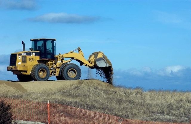
The second point is that the price can be shocking. To truck in sand and spread it along a beach may cost $30 to $40 per cubic yard; even a modest project can call for 100,000 cubic yards. And since no replenishment scheme lasts forever, towns and landowners must plan on redoing the job periodically — forever.
The only place to mine vast amounts of sand at a reasonable cost is offshore. And the Massachusetts Division of Marine Fisheries has considerable say over that. “That’s a major problem on the Island — it’s a huge sandbar, but there’s no place to get sand,” Ms. Marden said. Engineers can buy limited amounts for top dollar from sand pits on the Island, but from coastal or ocean waters, “you can’t get sand.”
The DMF is chiefly responsible for safeguarding habitat and breeding grounds for shellfish and finfish. There are concerns not only about disturbing the bottom where the sand might come from, but also on the beaches where it might go. The agency generally requires that sand be placed above the high tide line, because shellfish often live between that line and the water.
“We don’t have really solid understanding of how sea floor habitat results in fish productivity,” said Kathryn Ford, an environmental analyst at the DMF. “What’s really stymying us is a lack of information. So we end up being very precautionary, because we have to assume there’s a shellfish bed there, or we assume that this is an important shore zone fish area.”
Such a determination can stop a sand mining project cold. “Fisheries management is very strong and there can be impacts from mining the sand,” said Steven McKenna, the Cape Cod and Islands regional coordinator for the state office of Coastal Zone Management. “You’re disturbing habitat. That collides with the interests of landform protection, protection of beaches and properties. Up until now it’s really been extremely difficult and hasn’t been done on any scale offshore.”
But Mr. Keon, the Chatham coastal resources director, believes that with roads, public beaches, town properties and homes worth hundreds of millions of dollars at risk around the commonwealth, the argument may soon shift.
“I just think that to date, the reluctance of the fisheries arena to allow any kind of sand extraction — I have a feeling it’s going to get relaxed,” he says. “Because I think the pressures to the politicians, the policy makers and the regulatory writers — they are going to say, ‘You know what, we appreciate that, and we’re going to still protect resources, but that sand is going to become available for use because these communities have to do something to maintain themselves.’ I don’t think the first result is going to be, ‘Sorry. Take your house down.’ There’s too much economic incentive to not allow that.”
Projections In an Era of Retreat
Day and night the states of New York and New Jersey have pumped millions of cubic yards of sand onto their shorelines to rebuild them after Hurricane Sandy. Setting aside the issues of habitat, some ask why it is not possible to halt or at least slow the erosion of the southern coastline of Martha’s Vineyard the same way.
Experts interviewed by the Gazette say it will never happen. The Jersey coast, like the beaches in front of Miami or Santa Monica, are entirely engineered, designed and constantly replenished to defend hotels, condominiums and businesses from the rising sea, as well as to attract visitors by the millions to the shoreline.
“They realize that that is their lifeblood, in many ways the economic engine for the entire state,” said Mr. Keon, who served as chief of coastal planning for the Philadelphia district of the U.S. Army Corps of Engineers and helped devise many of the manmade beaches along the Jersey shore.
By contrast, the southern shoreline of the Vineyard is natural, largely undeveloped, mostly unpopulated and wildly exposed to the Atlantic. And in places where the beaches are privately owned, they are disqualified from sharing in the hundreds of millions of dollars in federal aid that it would take to nourish the public beaches to either side of them.
“You’ve got so much un-engineered, so much natural coastline on the Island, combined with just the mentality that’s out here — it’s so sensitive to environmental changes. [The Vineyard] really tries to actively protect it,” said Mr. McKenna of CZM. “I’ve seen some of the pushback against some of the projects seeking to armor out here, for instance, on a very small scale. I don’t know that there would be the collective will to be pursuing such a large-scale project.”
Meanwhile, people living on the cliffs, especially along the southern coastline, realize that the era of retreat has arrived. The beaches and bluffs have now backed up to those lines of supposed safety where so many houses were so recently built.
This year, some owners are moving their homes back at great expense; others are taking them down by order of the town. An aerial review of the 17-mile shoreline from Squibnocket east to Chappaquiddick shows that scores more owners will have to make the same difficult choices in the next few years. So will others on more protected coastlines on the northern side of the Island.
Towns themselves face costly decisions. The Gay Head Lighthouse must be moved within the next two years. Chilmark is just beginning to work out where to pull back a beachfront parking lot at Squibnocket and build a new road over to the seafront houses at Squibnocket Farm. Oak Bluffs confronts a slumping embankment and a threatened coastal road at East Chop.
“You live along this dynamic system and you need to understand that,” said Mr. Giese. “And come to the realization that there is no solution to this problem. It is an ongoing issue. And you’re trying to manage it as best you can. It isn’t a one-time thing.
“We as a species don’t like that because it’s expensive. We like to write a check once and walk away. Engineers — I’m not an engineer — like to design something that solves the problem. They hate coming into a commission where they can’t build a hard wall to solve a problem [or] build something that they know is going to fail. And beaches, by design, fail.”
Jo-Ann Taylor agrees. She is beginning to plan what she hopes will be a series of meetings with town officials and residents, year-round and seasonal, to coordinate a new human response to a prehistoric natural process.
“I think it’s time for people to look at some of these bigger pictures,” she said. “The forces are too powerful. Retreat is the only option. Retreat and retreat more.”